Minneapolis Neighborhood
St. Anthony West
The river end of Northeast — a half square mile between Broadway and the railroad tracks, named for the old east-bank town of St. Anthony, where three riverfront parks have replaced the log booms, paper mill and lumberyard that used to work this stretch of the Mississippi, and Kramarczuk's is a short walk south across the tracks.
№ 72 of 87 · Northeast community · Last updated: October 2026 · A complete neighborhood guide
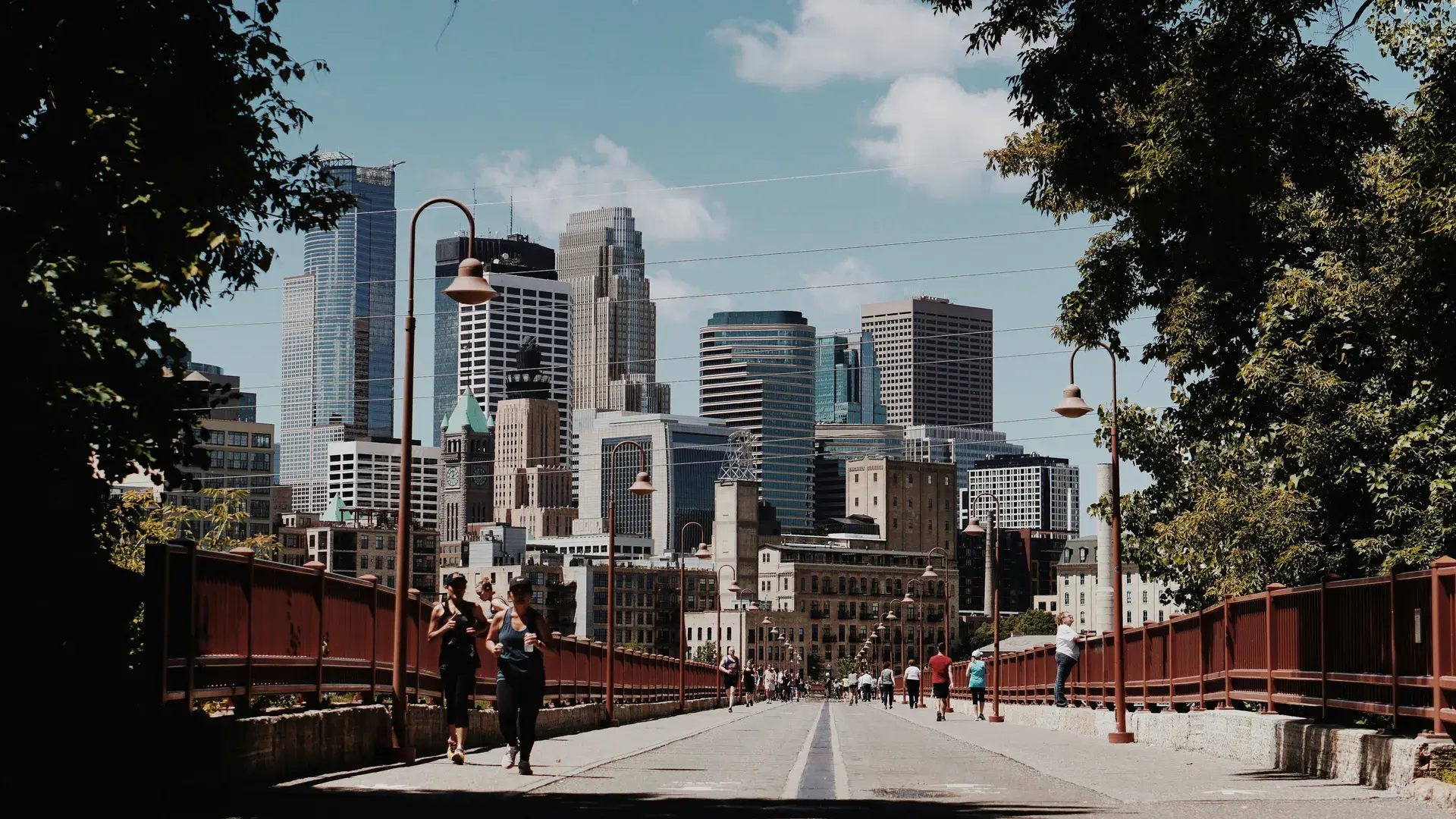
Walk out to the river's edge in Boom Island Park on a clear evening and look downriver. Nicollet Island splits the Mississippi in front of you, the east channel running along its near side, and past the island the downtown skyline rises on the far bank. The ground under your feet was an island once. Lumbermen used it to sort the logs floating down to the sawmills at St. Anthony Falls — that's where the boom in Boom Island comes from — until silt and sawdust filled in the channel and joined it to the shore. The falls themselves are a little under a mile downriver, out of sight past the island. They are the reason the town of St. Anthony grew up on this bank before Minneapolis existed, and the neighborhood that carries its name still feels like it belongs to the river first and the city second.
What is St. Anthony West, Minneapolis?
St. Anthony West sits on the east bank of the Mississippi River in Northeast Minneapolis, roughly bounded by the river to the west, Broadway Street NE to the north, Washington and 5th Streets NE to the east, and the river's east channel and the railroad tracks to the south. Across Broadway is Sheridan; across the tracks and the channel is Nicollet Island - East Bank. Its sibling, St. Anthony East, runs from Washington and 5th over to Central Avenue, and while the two are officially separate neighborhoods, they share a name and a history, and plenty of people who live here just call the whole area St. Anthony.
With roughly 2,400 residents on just under half a square mile, St. Anthony West is small by Minneapolis standards — small enough that neighbors recognize each other. Its defining feature is the Mississippi. The river forms the whole west edge, and most of the riverfront is parkland: Boom Island and B.F. Nelson, which give the neighborhood the largest share of Central Mississippi Riverfront Regional Park, and Graco Park, part of Above the Falls Regional Park. Inland, University Avenue NE, Main Street NE, Marshall Street NE, 2nd Street NE and 4th Street NE carry traffic through blocks of older houses and apartment buildings.
Today, St. Anthony West is a neighborhood of layers: older houses alongside newer apartment buildings, riverfront parks a block or two from busy arterials, Nicollet Island just across the east channel, and Graco's headquarters on the riverfront near the north end. It is increasingly popular with people who want river access and a short trip to downtown — about a mile from the neighborhood's southern end — without paying North Loop rents across the water.
St. Anthony West Neighborhood Sign
As far as we can tell, St. Anthony West doesn’t have a neighborhood welcome sign — at least, nobody has documented one that we can find. If you’ve seen one, tell us where it is — we’d love to be wrong about this.
St. Anthony West, Minneapolis — Key Stats (2025–2026)
- Residents (2020 Census)
- ~2,400
- Median sale price, homes and condos (2025 data)
- $400K
- Median rent, all units (2020–24 ACS)
- $1,866
- Walk Score (Oct 2026)
- 78
- Bike Score (Oct 2026)
- 96
- Transit Score (Oct 2026)
- 56
- Year the town of St. Anthony was platted
- 1849
- Year St. Anthony merged with Minneapolis
- 1872
St. Anthony History & Origins
The land around St. Anthony Falls is the ancestral homeland of the Dakota people, for whom the falls, called Owámniyomni, are a sacred site. People gathered there for thousands of years — Dakota, Ho-Chunk and Ojibwe people all camped near the falls — long before any European set eyes on them. Father Louis Hennepin, a Franciscan friar traveling with a French expedition, saw the falls in 1680 and named them after his patron saint, St. Anthony of Padua — a colonial renaming, though the Dakota name is in use again today. The falls sit about half a mile downriver from St. Anthony West's southern edge, and almost everything about the neighborhood's early history traces back to them.
In 1838, Franklin Steele claimed land on the east bank of the river beside the falls, and a settlement grew up around the sawmills that harnessed their power. St. Anthony was platted in 1849 and incorporated in 1855. The settlement on the west bank of the river, which would become Minneapolis, grew up alongside it and eventually outgrew it.
The two cities merged in 1872, and St. Anthony became part of Minneapolis rather than an independent municipality. The name survived on the east bank, and today two Northeast neighborhoods, St. Anthony West and St. Anthony East, carry it.
The river shaped this stretch of the east bank as working land. Boom Island got its name from the booms used to separate logs floating down the Mississippi to the sawmills at the falls; men working from the island read the stamp on each log and steered it to the right mill. Silt and sawdust eventually filled in the channel behind it and turned the island into a peninsula. Just downriver, Benjamin Franklin Nelson's paper mill and roofing materials business operated from the 1880s on the site that now carries his name, and upriver, Scherer Bros. Lumber ran a lumberyard for decades on the land that is now Graco Park.
The riverfront's turn from industry to parkland came slowly. The Park Board bought the Boom Island land in 1982, and the first phase of Boom Island Park was dedicated in 1987. The B.F. Nelson site had been acquired by the state in the 1970s for a planned I-335 freeway that was never built, and in 1987 MnDOT offered to sell it to the Park Board. The Park Board bought the Scherer Bros. lumberyard in 2010, agreements reached with Graco in 2018 brought more than $3 million from the Graco Foundation toward a park there, and the first phase of Graco Park opened in September 2024.
Living in St. Anthony
Living in St. Anthony West mostly means living near the river. The blocks between University Avenue and the water are a few minutes' walk from Boom Island, B.F. Nelson or Graco Park, and the East Bank Trail is how a lot of residents start or end the day. The neighborhood is mostly residential, with a few long-running businesses — a Lebanese deli, a bowling alley, a pizza place on Broadway — rather than a main street of its own. Graco's headquarters near the north end is a reminder that this was an industrial riverfront before it was a park.
The residential mix has shifted significantly over the past two decades. The neighborhood was historically working-class and middle-class — mill workers, tradespeople, small business owners, the kind of people who built solid houses on modest lots and stayed for generations. That population is still here. But increasingly, St. Anthony West is also attracting young professionals who work downtown and walk or bike over the river, couples who want riverfront living without North Loop rents, and empty-nesters downsizing from the suburbs who want walkability and the river close by.
The result is a neighborhood that feels more economically diverse than it probably is. Older houses sit next to newer apartment buildings. Kramarczuk's, just across the tracks on East Hennepin, still sells sausage by the pound to customers who have been coming for decades, and Emily's, on University Avenue, has been serving homemade Lebanese dishes since 1973. These layers coexist, sometimes uncomfortably, but the river and the parks give the neighborhood a pull that holds things together even as the demographics shift.
St. Anthony Food, Drink & Local Spots
St. Anthony West doesn't have a restaurant row. What it has is a handful of long-running places on its own streets — a Lebanese deli, a bowling alley with a kitchen, a wood-fired pizza place on Broadway — and a short walk to more. Kramarczuk's and Surdyk's are just south of the railroad tracks on East Hennepin, and the rest of Northeast's bars and restaurants start across Broadway. This is not Uptown or the North Loop, but what's here tends to have been here a while.
In the Neighborhood
641 University Ave. NE. A family-owned Lebanese deli that has been serving homemade dishes since 1973 — kibbi, kafta kabob, lamb shish kabob, stuffed grape leaves. It is the kind of place regulars order from without looking at the menu. Check the website before you go; it has been running on temporary hours.
729 Marshall St. NE. A restaurant and bar with 16 bowling lanes, a few blocks in from Boom Island. Cosmic bowling on weekends, bumpers if you bring kids, and a full kitchen and bar for the people waiting on a lane.
96 Broadway St. NE, on the St. Anthony West side of Broadway at the neighborhood's north edge. Neapolitan-style pizza from a wood-fired oven, a short walk from Graco Park.
Nearby
215 E. Hennepin Ave., just south of the railroad tracks in Nicollet Island - East Bank. Ukrainian refugees Wasyl and Anna Kramarczuk took over an old Minneapolis butcher shop in 1954 and renamed it; the business has been at this address since 1967 and was named one of the James Beard Foundation's America's Classics in 2013. Sausage, pierogi, cabbage rolls and a bakery counter. Point at what looks good, get more than you can eat, and come back for the bakery items next time.
303 E. Hennepin Ave., a block from Kramarczuk's in Nicollet Island - East Bank. Joseph Surdyk opened his first liquor store on East Hennepin in February 1934, right after Minneapolis legalized liquor sales again. The wine and spirits selection is one of the best in the Twin Cities, and the cheese shop could sustain a European picnic. The staff knows what they're talking about and will steer you toward something interesting without being pretentious about it.
125 Main St. SE, in Marcy-Holmes, a few blocks past the railroad tracks and East Hennepin. A candlelit dining room and a patio overlooking the Mississippi and the downtown skyline, with live music on the calendar. Reservations for the dining room; the patio is walk-in only.
1928 University Ave. NE, about a mile north up University Avenue in Bottineau. Jax got its liquor license when Prohibition ended in 1933 and has been serving steaks in the same building ever since. The patio has a trout stream where you can net your own dinner. It is a Minneapolis institution that has somehow resisted both closure and ironic reinvention.
Parks, River & Outdoors in St. Anthony
St. Anthony West is, first and foremost, a riverfront neighborhood. The Mississippi forms its entire west edge, and most of that riverfront is park. The neighborhood holds the largest share of Central Mississippi Riverfront Regional Park — more than any of the other neighborhoods it touches — and residents who choose St. Anthony West over other Minneapolis neighborhoods almost always cite the water as a primary reason.
The East Bank Trail
The Mississippi East Bank Trail runs through St. Anthony West's riverfront, linking Boom Island and Graco Park and heading north past Graco's headquarters to Sheridan Memorial Park. The paved trail provides dedicated space for walking, running, and biking, with views of the river, Nicollet Island and the downtown skyline.
From Boom Island, a pedestrian bridge crosses the east channel to Nicollet Island, and from there the Hennepin Avenue Bridge crosses to downtown. Heading south along the east bank instead, St. Anthony Falls is about half a mile from the neighborhood's southern edge. In 2025 the Park Board built a trail underpass beneath the Plymouth Avenue Bridge to link Graco Park directly with Boom Island.
Boom Island Park
Boom Island Park, at 724 Sibley Street NE, is the neighborhood's main riverfront park. It has picnic areas and grills, a playground, restrooms, walking and biking paths, and the small Boom Island lighthouse. The boat dock has been closed for construction until 2026, but there are canoe and kayak racks near the pedestrian bridge to Nicollet Island. The views from Boom Island — looking south past Nicollet Island toward the downtown skyline — are exceptional, particularly at sunset. The park is popular with families, picnickers, and paddlers.
B.F. Nelson Park
B.F. Nelson Park, at 434 Main Street NE, runs along the east channel just south of Boom Island, across from Nicollet Island. It has paved walking trails that connect to Boom Island and a free parking lot. The Pioneer Statue, a granite sculpture of a pioneer family of three generations, was moved here in 2010. The Park Board's plan for the site is to leave it mostly as green space connecting Boom Island and Nicollet Island, and it still feels that way: quiet, open, and close to the water.
Graco Park
Graco Park, at 810 Sibley Street NE just north of the Plymouth Avenue Bridge, is the newest of the three. The 9-acre former lumberyard opened its first phase in September 2024 with a segment of the East Bank Trail, a river walkway, a gravel landing for canoes and kayaks, an outdoor stage with grassy seating, a pollinator lawn and a public art installation called Timber Markers. The park includes the restored Hall's Island, and the River Hub, a park building with indoor programming space, opened in 2025.
Dickman Park
Away from the river, Dickman Park at 614 2nd Street NE is the neighborhood park: a wading pool, a playground, basketball and volleyball courts, a horseshoe pit and a community garden. It was named in 1955 for Ralph E. Dickman, a Northeast youth worker, attorney and Hennepin County commissioner. Sheridan Memorial Park is just across Broadway, and St. Anthony Park is just across the line in St. Anthony East.
St. Anthony Schools
Only a few percent of St. Anthony West households include children, by Census estimates, against about one in five citywide. Minneapolis Public Schools serves the area, and families navigate the same system of neighborhood schools, magnet programs, and open enrollment that operates citywide. Check the district's school finder for the current assignments for a specific address.
Webster Elementary, at 425 5th Street NE, sits just across 5th Street NE in St. Anthony East. Pillsbury Elementary, farther northeast, and Las Estrellas Dual Language Elementary, on University Avenue NE just across Broadway in Sheridan, are also among the options St. Anthony families consider. Edison High School, on 22nd Avenue NE, is the nearest comprehensive high school, and families who prioritize school rankings often explore the citywide magnet system or consider charter and private options — several parochial schools in Northeast Minneapolis draw on the area's Catholic heritage.
The honest assessment: St. Anthony is not yet a neighborhood where families move specifically for the schools — that distinction still belongs to the southwestern neighborhoods and the suburbs.
St. Anthony Real Estate & Housing
St. Anthony's housing market reflects a neighborhood in the middle of a long, slow transformation from working-class and middle-class to upper-middle and affluent. The process is further along here than in most of Northeast Minneapolis — the riverfront parks and the short trip to downtown have made St. Anthony West one of the more desirable addresses in Northeast for over a decade. But it is not yet the North Loop, directly across the river, where median rents run higher, and that gap creates an opportunity for renters who value the river over prestige.
Buying in St. Anthony
St. Anthony West's median sale price was $400,000 in 2025, according to Minneapolis Area REALTORS, down from $439,950 a year earlier — on just 12 sales, the figure swings from year to year. The owner-occupied market is unusually diverse for a neighborhood this size. Single-family homes range from modest early 20th century houses and workers' cottages to renovated older homes near the riverfront parks at the top of the market. Buyers who want a house with some age and character will find it here, though they should budget for the maintenance that 100-year-old buildings require.
Condos and townhomes are a large part of the market — eight of the neighborhood's 12 sales in 2025. Newer construction with river views and modern finishes sits at the top of that market and attracts buyers who want to live near the river without the responsibilities of a single-family home.
Rental Market
Census estimates put the median rent in St. Anthony West at about $1,870 a month across all units, with older walk-ups at the lower end and newer construction — particularly buildings with river views — at the higher end. That is well above the city's $1,371, the rest of Northeast, and Uptown and Whittier, though below the North Loop.
For renters, the value proposition is compelling: you get the riverfront parks, a walk or bike ride of about a mile to downtown, and Northeast's bars and restaurants close by, at prices that are significantly lower than comparable waterfront addresses in other major American cities. The trade-off is that the rental stock in older buildings can be dated, and the newer buildings — while offering modern amenities — sometimes lack the character that draws people to the neighborhood in the first place.
Getting Around St. Anthony
St. Anthony West is one of the more navigable neighborhoods in Minneapolis, benefiting from its compact size, proximity to downtown, and the bridges and trails that connect it to the rest of the city. The Walk Score of 78 reflects a neighborhood where parks, transit and a handful of local businesses are a short walk away, with more just outside its edges. The Bike Score of 96 is among the highest in the city and more accurately captures how most active residents get around: the East Bank Trail and the river bridges make cycling to downtown and to adjacent neighborhoods fast, flat, and scenic.
The main walking route downtown runs south across the railroad tracks to East Hennepin Avenue, then over Nicollet Island and the Hennepin Avenue Bridge — a 20- to 30-minute walk or 10-minute bike ride to the heart of downtown Minneapolis. The Plymouth Avenue Bridge, which lands at 8th Avenue NE, and the Broadway Avenue bridge on the neighborhood's north edge cross to the west bank, and the pedestrian bridge from Boom Island leads onto Nicollet Island. For commuters, the combination of bridge access and riverfront trails means that a car is optional for anyone who works downtown.
Transit service is adequate but not exceptional. Metro Transit's Route 11 runs along 2nd Street NE toward downtown, and Route 30 crosses Northeast on Broadway, stopping at Broadway and 2nd Street NE. The Transit Score of 56 is honest — transit works here, but most residents rely on biking or walking for daily trips and use transit as a supplement rather than a primary mode.
For drivers, University Avenue NE (Highway 47) runs north–south through the neighborhood, and the Broadway and Plymouth Avenue bridges are the quick ways across the river. Parking is generally manageable — most residential streets have free on-street parking. During summer weekends and events, parking near Boom Island and the other riverfront parks can be competitive — biking is the better option.
What's Changing: The Honest Version
St. Anthony West sits at the intersection of several tensions that are reshaping the neighborhood in real time. These are not abstract policy debates — they are arguments happening at neighborhood meetings, on Nextdoor, over fences between neighbors, and in the decisions that builders and buyers and renters make every day.
Development vs. Historic Character
The central tension in St. Anthony West is between the older, lower-scale character that makes the neighborhood desirable and the new development that threatens to dilute it. The riverfront parks, the older houses, the long-running local businesses — these are the things that draw people here. But the same desirability that attracts residents also attracts developers, and the pressure to build — more condos, more apartments, more mixed-use projects — is relentless.
Some new development has been sensitive to context: buildings that respect the neighborhood's scale and materials. Other projects have been less thoughtful — generic modern boxes that could be in any American city, dropped into a neighborhood whose identity depends on not looking like everywhere else.
The irony is familiar: people move to St. Anthony because it has character, and then the development that follows erodes the character that attracted them. The economics of real estate development favor maximum density and modern construction, and the gap between what the neighborhood wants and what the market delivers is a constant source of friction. The riverfront, at least, is largely settled: most of it is parkland now, and Graco Park was the last big piece.
Rising Prices & Economic Sorting
St. Anthony West was never a cheap neighborhood in the way that parts of North Minneapolis or even Logan Park were cheap a decade ago. But it was affordable by the standards of riverfront urban living — a place where a teacher or a city worker could buy a house and raise a family near the river without stretching beyond reason. That affordability is eroding. Home prices sit well above the city median, property taxes have followed, and the newer condo and apartment developments are aimed squarely at upper-middle-income buyers and renters.
The result is a gradual economic sorting that is changing who lives here. Long-time residents on fixed incomes feel the pressure of rising property taxes. Young adults and artists who might have rented here a decade ago are pushed to cheaper neighborhoods farther from the river. The working-class character that defined St. Anthony for most of its history is fading, replaced by a professional-class sensibility that values the neighborhood's setting but doesn't share its working-class roots. This is not unique to St. Anthony — it is the story of desirable urban neighborhoods across America — but it is felt here with particular sharpness because the neighborhood's history as a place where ordinary people lived and worked is so central to its identity.
Proximity to Downtown: Asset and Liability
Being about a mile from downtown Minneapolis is one of St. Anthony West's greatest assets. It is also, at times, a liability. The same bridges and trails that connect residents to downtown restaurants, offices, and cultural venues also connect downtown's challenges — homelessness, public safety incidents, property crime — to the neighborhood.
Residents discuss this openly and with varying degrees of frustration. Most acknowledge that urban living comes with urban realities and that St. Anthony's overall safety profile is strong by city standards. But the proximity to downtown means that issues — encampments, break-ins, public disorder — that might feel distant in Linden Hills or Tangletown feel close here. The neighborhood navigates this by staying engaged: active community organizations, communication with police and city officials, and the kind of neighborly vigilance that comes from people who care about where they live and intend to stay.
St. Anthony West FAQ
Is St. Anthony West a good neighborhood in Minneapolis?
For people who want to live on the river without living downtown, it's one of the better options in the city. Boom Island, B.F. Nelson and Graco Park take up most of the riverfront, riverfront trails connect all three, and downtown is about a mile away. The neighborhood itself is small and mostly residential, with a handful of long-running local businesses rather than a commercial strip — for a bigger restaurant scene you walk south across the tracks to East Hennepin or north into the rest of Northeast. The trade-off is prices above the city median and ongoing arguments about how much new development the area should take.
Is St. Anthony West, Minneapolis safe?
St. Anthony West is generally considered safe by Minneapolis standards. Steady foot and bike traffic along the riverfront trails helps. Property crime — package theft, car break-ins, occasional bike theft — occurs at rates comparable to other urban Minneapolis neighborhoods. As with any urban neighborhood, standard precautions apply: lock your bike, be aware of your surroundings at night, and don't leave valuables visible in your car.
What is the difference between St. Anthony East and St. Anthony West?
They are separate Minneapolis neighborhoods, divided by Washington Street NE and 5th Street NE. St. Anthony West has the riverfront: Boom Island, B.F. Nelson and Graco Park, plus University Avenue, Main Street NE and Marshall Street NE. St. Anthony East runs from that line over to Central Avenue and is more residential, with Webster Elementary just across 5th Street NE from St. Anthony West and St. Anthony Park inside its borders. Both carry the name of the old town of St. Anthony, and plenty of people just call the whole area St. Anthony.
What is St. Anthony Main?
St. Anthony Main is the mixed-use riverfront district along Main Street SE, near the Hennepin Avenue Bridge. Despite the name, it isn't in St. Anthony West: it sits south of the railroad tracks, mostly in Marcy-Holmes, a few blocks past St. Anthony West's southern edge. From the neighborhood, the walk there runs across the tracks and past Kramarczuk's on East Hennepin.
Can you walk to downtown Minneapolis from St. Anthony West?
Yes. Downtown is about a mile from the southern end of the neighborhood and about a mile and a quarter from the middle of it. The usual route is south across the railroad tracks to East Hennepin Avenue, then across Nicollet Island and the Hennepin Avenue Bridge — roughly 20 to 30 minutes on foot to the center of downtown. Farther north, the Plymouth Avenue Bridge at 8th Avenue NE and the Broadway Avenue bridge cross the river to the west bank. The East Bank Trail also runs south through the riverfront parks, and the footbridge from Boom Island puts you on Nicollet Island.
What is Nicollet Island?
Nicollet Island is the island in the Mississippi just south of St. Anthony West, across the river's east channel. It's part of a different neighborhood, Nicollet Island - East Bank, and it has a small cluster of old houses, the Nicollet Island Inn, the Nicollet Island Pavilion and Nicollet Island Park. From St. Anthony West, the easiest way onto the island on foot is the pedestrian bridge at Boom Island Park.
How much does it cost to live in St. Anthony West?
St. Anthony West is one of the pricier neighborhoods in Northeast Minneapolis. Its median sale price was $400,000 in 2025, according to Minneapolis Area REALTORS, well above the city's $350,000 — though that figure rests on just 12 sales, two-thirds of them condos or townhomes. Census estimates put the median rent across all units at about $1,870 a month, well above the city's $1,371. The neighborhood costs more than most of Northeast; rents run below the North Loop's, directly across the river, and sale prices are well below the lakes neighborhoods in Southwest Minneapolis.
What restaurants are in St. Anthony West?
Inside the neighborhood, the long-runners are Emily's Lebanese Deli on University Avenue NE, family-owned since 1973, and Elsie's on Marshall Street NE, a restaurant and bar with 16 bowling lanes. Element Wood Fire Pizza is on Broadway at the north edge. Just south of the railroad tracks on East Hennepin, in Nicollet Island - East Bank, are Kramarczuk's, making sausage since 1954, and Surdyk's, the liquor and cheese shop that opened in 1934. A bit farther out are Aster Cafe on Main Street SE in Marcy-Holmes and Jax Cafe, about a mile north up University Avenue in Bottineau.
Is St. Anthony West walkable?
Yes, with a caveat. The Walk Score of 78 reflects short walks to parks, transit and the handful of businesses in and around the neighborhood, but the bigger concentrations of restaurants and shops are just outside it — south across the tracks on East Hennepin and in Sheridan and the rest of Northeast to the north. The Bike Score of 96 is the more telling number: the neighborhood is flat, the East Bank Trail runs through its riverfront parks, and downtown is about a mile away.
What parks are in St. Anthony West?
Boom Island Park, B.F. Nelson Park and Graco Park line the riverfront. Boom Island and B.F. Nelson give the neighborhood the biggest share of Central Mississippi Riverfront Regional Park; Graco Park is part of Above the Falls Regional Park. Boom Island has picnic shelters, a playground, the little Boom Island lighthouse and a footbridge to Nicollet Island. B.F. Nelson is mostly open green space along the east channel. Graco Park, a former lumberyard, opened its first phase in 2024 with a river walkway, a canoe and kayak landing and an outdoor stage. Away from the river, Dickman Park on 2nd Street NE has a wading pool, playground, courts and a community garden.
Is St. Anthony West gentrifying?
St. Anthony West's story is different from many Minneapolis neighborhoods because its biggest changes have been on the riverfront, where industrial land became parkland: land bought from a construction company became Boom Island Park, a freeway site that was never used became B.F. Nelson Park, and a lumberyard became Graco Park. Those parks, plus the short trip to downtown, have pushed demand and prices up. New construction skews toward higher-end apartments and condos, and the older housing stock is increasingly out of reach for first-time buyers. The tension is less about 'who was here first' and more about whether the neighborhood can keep its economic mix as its cachet grows.
What Makes St. Anthony West Irreplaceable
St. Anthony West sits right on the Mississippi. Most of its riverfront spent a century as working land — the log booms on Boom Island, the B.F. Nelson paper and roofing works, the Scherer Bros. lumberyard — and over forty years the Park Board turned it, piece by piece, into public ground. Boom Island was dedicated in 1987, B.F. Nelson followed after the freeway that was supposed to run through it was abandoned, and Graco Park opened in 2024. The result is a run of parks from Graco Park down to the east channel, with Nicollet Island and the downtown skyline across the water.
What makes St. Anthony West worth caring about is that it has managed — so far — to carry its history into the present without embalming it. Emily's has been serving kibbi since 1973. Elsie's still has 16 lanes of bowling on Marshall Street. Kramarczuk's, just across the tracks, still makes sausage the way Wasyl and Anna Kramarczuk did when they took over a butcher shop in 1954. New buildings have arrived, and not all of them honor what was here before — but most of the riverfront is parkland now, and that is not the kind of thing a developer can undo. The question for St. Anthony West is not whether it will survive. It is whether it will remember what it is. Walk out to the end of Boom Island on a quiet evening, with the river splitting around Nicollet Island in front of you, and you will understand why people keep wanting to live here.

From the shop
Made for people who love it here.
From Minneapolis, With Love - Large Tote Bag
Keep exploring