Minneapolis Transit: The Honest Overview
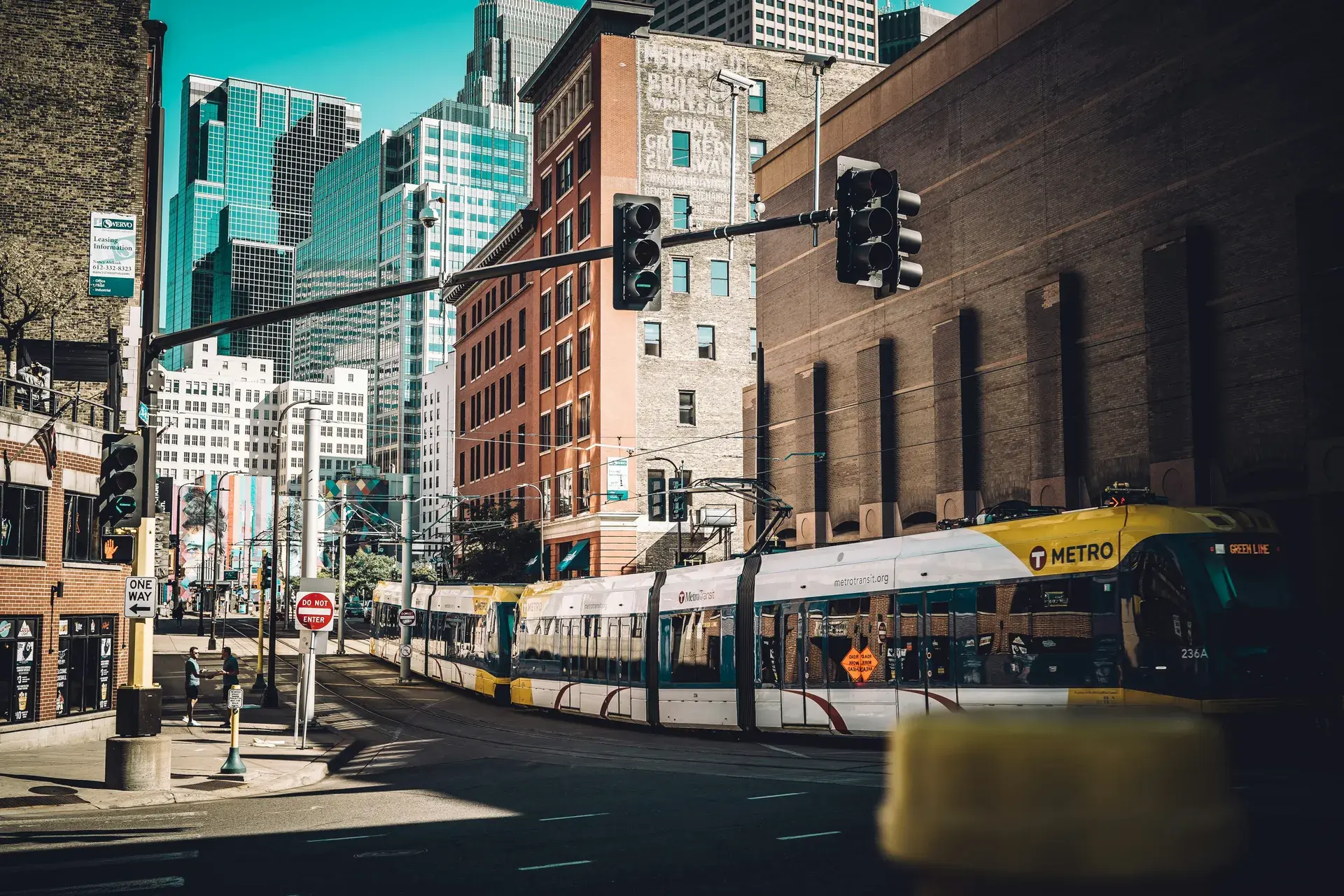
Metro Transit operates two light rail lines: the Blue Line (running from Target Field through downtown to the airport and Mall of America) and the Green Line(running from Target Field through the U of M campus to downtown St. Paul). The bus network covers the city with varying frequency — some routes run every 10 minutes during rush hour, others every 30-60 minutes.
The honest truth: Minneapolis transit works well for commuting to downtown and for trips along the light rail corridors. It is less useful for cross-town trips, suburban destinations, and late-night travel. Most transit-dependent Minneapolis residents supplement with biking (in season) and occasional rideshares. True car-free living is possible in the top neighborhoods below; car-light living is more realistic for most.
Downtown East
Transit Score
85
Light Rail
Blue Line + Green Line (Government Plaza, US Bank Stadium)
Downtown Commute
0 min (you are downtown)
Car-Free?
Excellent
Key bus routes: Multiple high-frequency routes
Downtown East is the transit hub of Minneapolis. The Government Plaza and US Bank Stadium stations put both light rail lines within walking distance of any point in the neighborhood. The Blue Line runs to the airport (25 minutes) and Mall of America (35 minutes). The Green Line runs to the University of Minnesota (10 minutes) and downtown St. Paul (40 minutes). High-frequency bus routes radiate outward in every direction. The skyway system adds a climate-controlled pedestrian network. Car-free living here is not a compromise — it is the logical choice. The tradeoff: Downtown East transit is optimized for commuters and event-goers. Late-night service is limited (last trains around midnight), and weekend frequency drops. If your lifestyle involves leaving downtown regularly for non-work destinations, the transit advantage diminishes.
Read the full Downtown East guide →Downtown West
Transit Score
82
Light Rail
Blue Line + Green Line (Nicollet Mall, Warehouse District)
Downtown Commute
0 min (you are downtown)
Car-Free?
Excellent
Key bus routes: Routes 4, 6, 10, 17, 18 + multiple express routes
Downtown West matches Downtown East on transit fundamentals — both light rail lines, high-frequency buses, skyway access. The Nicollet Mall station and Warehouse District station provide convenient access to the entire light rail system. The bus network is slightly denser here because Hennepin and Nicollet avenues serve as major bus corridors. Target Center and the Hennepin Theatre District mean you can attend events without driving. The same late-night and weekend frequency limitations apply. Downtown West is also slightly more walkable to the North Loop, which extends your car-free radius for dining and entertainment.
Read the full Downtown West guide →North Loop
Transit Score
78
Light Rail
Blue Line (Target Field) + Green Line (Target Field)
Downtown Commute
5-10 min by light rail or 15 min walk
Car-Free?
Very Good
Key bus routes: Routes 7, 22, limited others
The North Loop benefits from the Target Field light rail station, which is the transfer point between the Blue and Green lines. This gives you direct rail access to the airport, Mall of America, U of M, and St. Paul from a single station. The walkable density of the neighborhood means most daily needs are covered on foot — grocery, dining, coffee, fitness — so transit is primarily for longer trips. The limitation: bus service within the North Loop is thin compared to downtown. If your destination is not on a light rail line, you may be walking to downtown to catch a bus or using a rideshare. Car-free living is very doable if your life is organized around the light rail corridors; it gets harder if you regularly need to reach suburban destinations.
Read the full North Loop guide →Marcy-Holmes
Transit Score
72
Light Rail
Green Line (East Bank, Stadium Village stations)
Downtown Commute
10 min by Green Line
Car-Free?
Very Good
Key bus routes: Routes 2, 3, 6, campus shuttles
Marcy-Holmes sits at the western edge of the University of Minnesota campus, which makes the Green Line light rail its transit backbone. The East Bank station is a 5-10 minute walk from most of the neighborhood, providing direct service to downtown Minneapolis (10 minutes) and downtown St. Paul (35 minutes). University bus routes supplement the light rail. The neighborhood is one of the most bikeable in the city, and the Stone Arch Bridge provides a beautiful pedestrian/bike route to downtown. Car-free living works well here, especially for people connected to the U of M ecosystem. The limitation: north-south transit is weaker. Getting to South Minneapolis neighborhoods by transit requires transfers and patience.
Read the full Marcy-Holmes guide →Cedar-Riverside
Transit Score
70
Light Rail
Green Line (West Bank station)
Downtown Commute
8 min by Green Line
Car-Free?
Very Good
Key bus routes: Routes 2, 7, 22
Cedar-Riverside has the West Bank light rail station, putting the Green Line within walking distance of the entire neighborhood. The station is right at the edge of the U of M West Bank campus, making this an excellent transit neighborhood for students, faculty, and hospital workers (HCMC and the U of M Medical Center are both accessible by transit). The neighborhood is also one of the most walkable for daily errands — the Cedar-Riverside commercial district along Cedar Avenue has grocery stores, restaurants, and services that serve the large Somali and East African community. Car-free living is not just viable here — it is how many residents actually live. The tradeoff: late-night safety concerns around the light rail station are real and worth acknowledging.
Read the full Cedar-Riverside guide →South Uptown
Transit Score
62
Light Rail
None (nearest: Lake Street/Midtown station, 1+ mile)
Downtown Commute
15-20 min by bus
Car-Free?
Good
Key bus routes: Route 6 (Hennepin), Route 4 (Lyndale), Route 21 (Lake St)
South Uptown does not have light rail, but it has something almost as useful: three high-frequency bus corridors converging in a small area. Route 6 on Hennepin runs every 10-15 minutes to downtown. Route 4 on Lyndale provides north-south service. Route 21 on Lake Street is one of Metro Transit's busiest routes, connecting Uptown to the Midtown Greenway corridor and points east and west. The Midtown Greenway itself functions as a transit corridor for cyclists — a flat, separated bike path that connects to downtown in 15 minutes. Car-free living works in South Uptown if you combine bus and bike. The limitation: no light rail means no direct airport or St. Paul access without a transfer, and bus frequency drops after 10 PM.
Read the full South Uptown guide →Whittier
Transit Score
64
Light Rail
None (nearest: Franklin station on Blue Line, 0.5 mile east)
Downtown Commute
15-20 min by bus
Car-Free?
Good
Key bus routes: Route 18 (Nicollet), Route 4 (Lyndale), Route 2 (Franklin)
Whittier's transit story centers on the Nicollet Avenue bus — Route 18, which runs the length of Nicollet from downtown through Eat Street and south. It is not the fastest bus in the system, but it is frequent and connects Whittier to downtown reliably. The Lyndale Avenue bus (Route 4) provides a parallel corridor. Whittier is close enough to the Blue Line's Franklin station that some residents walk to light rail for airport trips. The neighborhood's real transit advantage is that its density of amenities reduces the need for transit in the first place — most daily errands are walkable. Car-free living in Whittier is good for people who primarily need downtown access and can walk or bike for everything else.
Read the full Whittier guide →Longfellow
Transit Score
50
Light Rail
Blue Line (46th Street station)
Downtown Commute
20-25 min by Blue Line
Car-Free?
Moderate
Key bus routes: Route 21 (Lake Street), Route 7 (limited)
Longfellow's transit anchor is the Blue Line light rail station at 46th Street, which provides direct service to downtown (20 minutes), the airport (10 minutes), and Mall of America (15 minutes). If you live near the station, this is a genuine asset — airport access alone justifies transit-oriented living. Route 21 on Lake Street adds an east-west bus corridor. The limitation: the 46th Street station is at the southern end of Longfellow, and much of the neighborhood is a 15-20 minute walk from the platform. Transit access in Longfellow is a spectrum: excellent near the station, mediocre in the northern half. The Midtown Greenway runs through the neighborhood, making bike-to-transit a viable commute strategy. Car-free living is possible but requires intentionality and a willingness to bike.
Read the full Longfellow guide →Phillips
Transit Score
58
Light Rail
Blue Line (Franklin & Lake Street stations, eastern edge)
Downtown Commute
15-20 min by bus, 10-15 by Blue Line
Car-Free?
Moderate-Good
Key bus routes: Route 21 (Lake Street), Route 2 (Franklin), Route 5 (Chicago Ave)
Phillips is one of the most transit-dependent neighborhoods in Minneapolis — not because the transit is great, but because car ownership rates are lower here than in almost any other neighborhood. The Blue Line's Franklin and Lake Street stations are accessible from the eastern edge of Phillips. Three bus routes (21, 2, and 5) provide reasonable coverage. Route 5 on Chicago Avenue is an underappreciated corridor that connects Phillips to downtown efficiently. The neighborhood's central location means biking to downtown takes only 10-15 minutes. Car-free living is the reality for many Phillips residents, and the transit infrastructure is adequate but not excellent. More frequency, especially on Route 5, would make a meaningful difference in daily life here.
Read the full Phillips guide →Elliot Park
Transit Score
65
Light Rail
Blue Line + Green Line (nearby downtown stations)
Downtown Commute
5 min walk or 1 stop on light rail
Car-Free?
Good
Key bus routes: Route 7, Route 22, proximity to downtown bus hub
Elliot Park is technically the southern edge of downtown, and its transit advantage comes from proximity to the downtown bus and rail network rather than dedicated neighborhood service. Walk 5-10 minutes north and you are at a light rail station. Walk 5 minutes west and you are on Nicollet Mall with multiple bus options. The neighborhood is anchored by HCMC (Hennepin Healthcare), which generates its own transit demand — many hospital workers commute by bus or train. Elliot Park is also one of the most centrally located neighborhoods for biking, with downtown, the Greenway, and the river trails all within easy reach. The tradeoff: Elliot Park is in the middle of a dramatic transformation — new apartment towers, convention center expansion, and street reconstruction — that will likely improve transit access over the next few years but currently creates construction-related disruptions.
Read the full Elliot Park guide →A Note on Biking as Transit
Any honest guide to Minneapolis transit has to acknowledge that biking is, functionally, part of the transit system. The Midtown Greenway, the Chain of Lakes paths, the riverfront trails, and the city's extensive bike lane network mean that a bike extends your effective transit radius by miles. Many Minneapolis residents who describe themselves as “car-free” are really “bike + transit” — using light rail or buses for longer trips and biking for everything else.
This works from April through October. From November through March, the dedicated winter cyclists continue (Minneapolis has one of the highest winter cycling rates in America), but most people shift to transit-only or add rideshares. If you are planning car-free living in Minneapolis, build your plan around the winter months, not the summer ones.
More Livability Guides
Transit is one piece of the livability puzzle. Our other guides cover walkability, winter survival, cost of living, and what each neighborhood is actually like to live in.
Love your city.
Gear that celebrates Minneapolis — made for the people who call it home.


